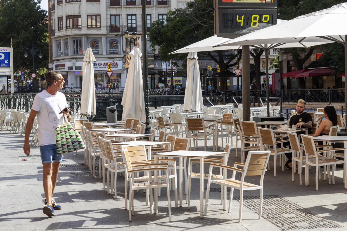
Madrid, Jul 12 (EFE).- The State Meteorological Agency (Aemet) foresees rising maximum temperatures for this Wednesday in the extreme south of the peninsula, Alborán and the Canary Islands, although there will be a decrease in the rest of the country, notable in the Ebro The 34-36 degrees will be exceeded in the southern half, interior northeast and archipelagos, even 38-44 degrees in Andalusia and interior southeast.
The minimum temperatures will rise in the extreme southeast of the peninsula, Alborán and the Canary Islands and will descend in the center.
Stable weather is expected in most of the country, with a predominance of slightly cloudy or clear skies in the southern half of the peninsula and the Balearic Islands.
However, in the Cantabrian area, cloudy skies are expected, with a probability of weak rainfall that will tend to subside on the coasts, dispersing in the afternoon in the form of showers in the interior, without ruling out that they affect Galicia.
In the rest of the northern half, the intervals of medium and high clouds will increase. In the afternoon, intervals of evolution clouds are probable in inland areas of the eastern third of the peninsula, without completely ruling out an isolated dry storm. In the Canary Islands cloudy intervals.
Calimas in the Canary Islands, without ruling them out in the southeastern third of the peninsula and the Balearic Islands. Probable morning fog banks in high areas of the northern third, as well as some coastal fog in Cádiz and Málaga.
North component wind in the northern third of the peninsula, with strong intervals in Ampurdán. From the west in the center and south, of variable direction in the Balearic Islands and trade winds with strong intervals in the Canary Islands.
PREDICTION BY AUTONOMOUS COMMUNITIES:
—————————————————————
– GALICIA: light rains in the northeastern third, more likely in La Mariña from Lugo. Maximum temperatures decreasing in the extreme north and minimum temperatures increasing in the Miño valley. Light wind from the north component, with more intense intervals on the Atlantic coast in the afternoon.
– ASTURIAS: cloudy sky with generalized light rains and occasional storms during the central hours in the Cordillera, where mists and probable morning mists will also occur. Notable drop in maximum temperatures in the interior of the eastern half; minimums increasing on the western coast. Light wind from north and northwest directions.
– CANTABRIA: light rains throughout the territory with mists and probable morning mists in the Cordillera, where stormy episodes can occasionally occur during central hours. Decreasing maximum temperatures in the far south. Light wind from north and northwest directions.
– BASQUE COUNTRY: cloudy skies and probable light rains except in the south, where clearings will open. Maximum temperatures decreasing in the interior of Guipúzcoa and in Álava. Light wind from north and northwest directions, with more intense intervals in the south of Álava in the afternoon.
– CASTILLA Y LEÓN: banks of low clouds in the mountainous systems of the north and northeast, as well as in the north of Burgos, and intervals of high clouds in the rest, although with a probability of medium clouds and cloudiness of evolution in the afternoon that will go from west to east; Weak precipitations are not ruled out in the Cantabrian and Iberian Mountains, occasionally accompanied by storms. Falling temperatures, locally notable in the maximum, especially in the eastern half. Loose wind from northeast or northwest directions that will tend to a west component in the central hours.
– NAVARRE: cloudy skies in the extreme north and northwest with possible light rains on the Cantabrian slope and the Pyrenees; little cloudy in the rest. Maximum temperatures in notable decrease except in the northwest third, where they will decrease slightly or remain with little change; minimums in descent in the Ribera. Light wind from north and northwest directions, more intense in the Ribera del Ebro.
– LA RIOJA: intervals of high clouds, and medium ones at the end of the afternoon that could leave some precipitation in the Iberian region; In the Sierra and the Rioja Alta, banks of low clouds will form at the end of the day. Declining temperatures, notable in the maximum. Variable light wind, which will tend to the northeast in the Rioja Alta and to the north throughout the territory during the second half of the day.
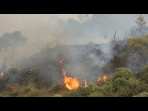
– ARAGÓN: probable scattered showers with storms in the Pyrenees divide and slightly cloudy skies with intervals of high clouds in the rest; in the east of Teruel, cloudy intervals of diurnal evolution from noon that may leave occasional storms. Declining temperatures, locally notable from the maximum in the Ebro depression, although it may still exceed 36 degrees in its eastern half and in points to the west of Teruel. Moderate wind from the northwest direction in the Ebro depression and light variable in the rest, although it will tend to the southwest in the western Iberian System in the afternoon.
– CATALONIA: cloudy skies and scattered rainfall with occasional storms in the Aran Valley starting at noon; it is probable that the rains spread to the rest of the Pyrenees in the form of occasional showers. Maximum temperatures in decline in the northern and southern third of Lleida, although it can reach 35-37 degrees in large areas of the interior; minimums without changes or in slight decrease. In the Ampurdán, a moderate wind from the north in the morning and at the end of the day, although in the afternoon it will turn east; variable weak in the rest, although it will tend to the southern components in inland areas and east in coastal areas.
– EXTREMADURA: clear sky and intervals of high clouds. Falling temperatures. Light wind from the west component.
– COMMUNITY OF MADRID: slightly cloudy sky with intervals of high clouds, average in the north during the central hours. Falling temperatures, notable in the mountains. Variable loose wind that in the central hours will tend to the west component.
– CASTILLA-LA MANCHA: probable haze in the south of Albacete, which can spread to the rest of the southeastern half, and evolving cloudiness in the extreme southeast without ruling out an isolated storm. Decreasing temperatures, locally notable from the maximums in the Central System, although with a slight rise in the extreme southeast; the minimums will rise in Albacete and will experience few changes in the south of Cuenca. Light wind from the west component, with more intense intervals from noon.
– VALENCIAN COMMUNITY: predominance of slightly cloudy skies without ruling out evolutionary cloudiness and occasional storms in inland areas starting at noon; probability of haze in the southern third and of suspended dust in high areas of the rest of the region. Maximum temperatures with few changes on the northern coast and decreasing in the rest, with values that may reach 40 degrees in inland areas of Valencia and Alicante; minimums in descent in the interior of Castellón and in ascent in Alicante. Light to moderate wind from north and east components on the coast and variable light in the interior.
– MURCIA: slightly cloudy or clear skies, with evolving cloudiness in the inland mountains, where isolated storms are not ruled out. General rising temperatures. Variable wind.
– BALEARIC ISLANDS: morning mists and suspended dust. Maximum temperatures decreasing in the north of the islands and minimum temperatures increasing, locally notable on the northern slopes of the Sierra de Tramuntana. Light wind with coastal breezes, from a southeasterly direction that will turn northeast at dawn.
– ANDALUSIA: slightly cloudy or clear skies, although with cloudiness of daytime evolution and possible isolated storms in the western interior; Neither are fog banks ruled out on the coast during the early morning or haze in the southeastern third of the autonomous community. Rising temperatures, locally noticeable, on the Mediterranean slope. West component wind, more intense in the eastern interior and the Strait.
– CANARY ISLANDS: little cloudy or clear skies in general and haze that will affect the midlands and highlands, most noticeable in Lanzarote, Fuerteventura, Gran Canaria and Tenerife. Temperatures in slight to moderate rise, more pronounced in inland areas and southern slopes, where the maximum will be significantly high; There will be yellow warnings on all the islands, between 34 and 36 degrees, and orange warnings in the south of Gran Canaria and Tenerife, between 37 and 38 degrees. Moderate northeasterly wind, with strong intervals on the southeast and northwest slopes, and locally very strong gusts.