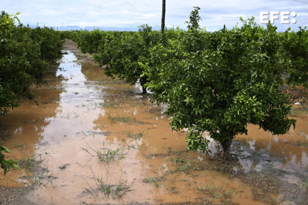
Madrid, May 10 (EFE).- The frontal system that moves from west to east will continue to leave weak rainfall this Wednesday in the extreme north of the peninsula and the Balearic Islands, although it will be somewhat more intense in the northeast of Catalonia, where there may be some storms , as reported by the State Meteorological Agency (Aemet). The temperatures, practically without changes.
In the southern third of the peninsula, slightly cloudy skies will predominate, and in the rest of the peninsula there will be medium and high cloud intervals, with the snow level in the Pyrenees at 1,800 meters dropping to 1,500, with weak frosts but with low probability of snowfall.
In the Canary Islands there will be low clouds in the north of the islands of greater relief and it will be slightly cloudy or clear in the rest of the archipelago, without ruling out some high and thin haze, with a slight rise in temperatures and intervals of strong winds from the northeast.
The temperatures will change little, although the maximum will drop, especially in Mallorca, Aragon and areas of the Valencian Community and Andalusia, but they will continue to comfortably exceed 30 degrees in the Guadalquivir valley, the interior of Huelva and the south of Gran Canaria.
The wind will blow strong or with strong intervals in the Ampurdán and the lower Ebro, with a predominance of the northern component throughout the country. In the Strait and Alborán they will tend to blow from the east.
PREDICTION BY AUTONOMOUS COMMUNITIES:
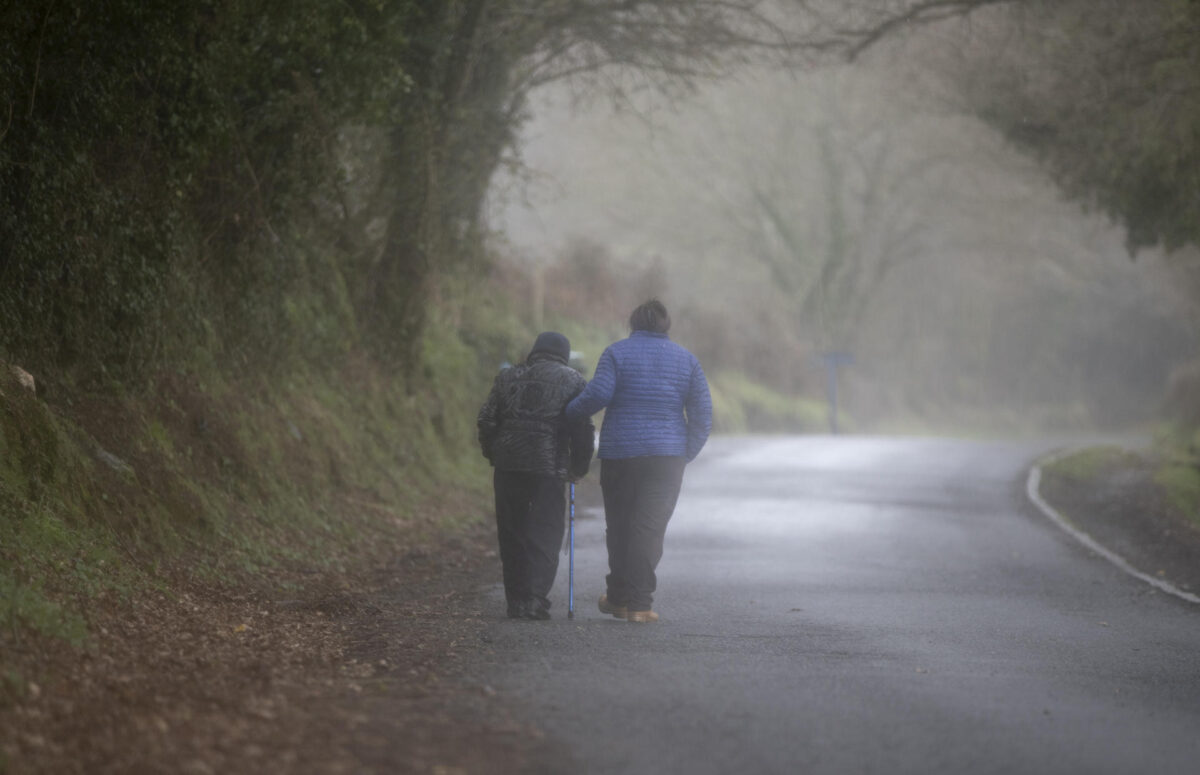
– GALICIA: mists and some morning fog banks in the Montaña de Lugo. Predominance of cloudy skies, with a majority of high clouds in the extreme southeast and on the west coast. Scattered drizzles in the northern third that are not expected on the west coast of A Coruña. Declining temperatures that, except in Ourense, will be slight or without changes to the minimum. Wind from the north and northwest, generally light in the interior and with strong intervals starting in the afternoon on the coast of Pontevedra.
– ASTURIAS: mists and some fog banks in the interior of the western third. Cloudy, with some clearings at dawn in flat areas of the interior, with drizzles and occasional light rains on the coast in the first half of the day accompanied by scattered showers in the interior in the afternoon. Falling temperatures. Weak frosts on peaks. Loose wind from the northwest and north in the interior and somewhat more intense and from the west and northwest on the coast.
– CANTABRIA: cloudy, with drizzles and occasional light rains on the coast, somewhat more intense inland. Declining temperatures that, except in the southwest, will be slight or without changes to the minimum. Weak frosts in southwestern peaks. Wind from the west and northwest on the coast and light from the north and northwest in the interior.
– BASQUE COUNTRY: cloudy or covered with drizzle and occasional light rain, unlikely in the south of Álava. Falling temperatures that will generally be light from the minimum in the north. Wind from the northwest and west, loose in the interior.
– CASTILLA Y LEÓN: mists and some morning fog banks are not ruled out. In the northeast and extreme north, cloudy skies without ruling out weak precipitations, and in the rest little cloudy with cloudy intervals of medium and high clouds. Falling temperatures. North and northeast wind.
– NAVARRE: cloudy or overcast, although with large clearings in the Ribera Baja at dawn and from the afternoon. Light rains in the northwest and in the far north. Falling temperatures. Weak frosts on the peaks of the Pyrenees. Loose northwest wind, more intense during the central hours.
– LA RIOJA: in the Rioja Alta, cloudy skies without ruling out some occasional weak rainfall, while in the rest little cloudiness with cloudy intervals of medium and high clouds. Falling temperatures. North and northwest wind.
– ARAGÓN: on the Pyrenees divide, cloudy skies with probable rainfall, weak in general, with the snow level between 1,400 and 1,800 meters. In Teruel, west of Zaragoza and Jacetania, cloudy intervals. In the rest, slightly cloudy skies with intervals of high clouds. Falling temperatures. Wind from north and west components.
– CATALONIA: at the Pyrenees divide and in the Aran Valley, cloudy skies with probable rainfall throughout the day, weak in general. In the eastern half, cloudy intervals, with a low probability of showers on the coast, and cloudy skies with probable showers, mainly inland. In the rest, a predominance of little cloudy or clear skies. On the Tarragona coast, cloudy intervals in the early hours and a low probability of isolated showers. The snow level between 1,600 and 2,000 meters. Falling temperatures.
In the Ampurdán, north wind with very strong gusts in the north of the region; in Tarragona and south of Lleida, wind from the west and northwest with very strong gusts in the south of Tarragona; in Barcelona, variable light wind in the morning and from the southeast in the afternoon; in the rest, variable light wind.
– EXTREMADURA: slightly cloudy, with intervals of medium and high clouds. Temperatures in slight decrease in the north and without changes in the south. Light northwest or north winds, more intense in the north.
– COMMUNITY OF MADRID: intervals of high clouds increasing to intervals of medium and high clouds. Falling temperatures, milder in general in the highs. Light north and northeast winds that will show stronger intervals at the end of the afternoon.
– CASTILLA-LA MANCHA: intervals of high clouds that will increase to cloudy intervals of medium and high clouds, with clouds of diurnal evolution. Decreasing minimum temperatures throughout the northern half, with the exception of Ciudad Real and northern and southern inland areas of Albacete where few changes are expected; falling maximum temperatures. Light winds with a predominance of the northern component that will show stronger intervals.
– VALENCIAN COMMUNITY: predominance of slightly cloudy skies with intervals of high clouds and cloudiness of diurnal evolution. Minimum temperatures without changes or in slight decrease and maximum in decrease. In the northern interior of Castellón, a northwesterly wind with very strong gusts during the first half of the day; in the rest of Castellón, wind from the northwest at first, turning to the southeast; in Valencia and Alicante, east component wind.
– REGION OF MURCIA: slightly cloudy skies with intervals of high clouds, and cloudiness of diurnal evolution in the interior mountains. Minimum temperatures with little change; maximums in descent in the interior, notable in the interior sierras, and without changes in the coast. East component winds, more intense on the coast, where they will tend to decrease in the afternoon.
– BALEARIC ISLANDS: in Mallorca, cloudy with rain and showers; in the rest, cloudy intervals with a low probability of some occasional precipitation. Nighttime temperatures with few changes or rising, the minimum will occur at the end of the day, and daytime temperatures in a locally notable decline. Wind from the north and northeast, tending to an easterly component in Mallorca and the Pitiusas.
– ANDALUSIA: slightly cloudy skies with intervals of high clouds, and evolutionary cloudiness in the eastern mountains. Minimum temperatures with slight changes; decreasing maximums, locally notable on the Mediterranean slope, except in the western interior where they will remain unchanged. Variable winds with a predominance of the north component, turning east during the morning on the Mediterranean coast with strong intervals during the change; and west component in the afternoon on the Atlantic slope.
– CANARY ISLANDS: predominance of slightly cloudy or clear skies, with cloudy intervals in low-lying areas to the north and east of the higher relief islands, especially during the first half of the day. Slight haze in height affecting mainly the eastern islands.
Temperatures with slight rises in the interior of the islands, especially in the midlands of northern Gran Canaria where the rises could be moderate or notable. It may reach or exceed 32 ºC in the interior and southwest of Gran Canaria and Fuerteventura, without ruling out that it will reach 30 ºC in other areas of the eastern islands and the southern half of Tenerife.
Moderate to strong northeast wind, with probable very strong gusts on the southeast and northwest slopes of the most mountainous islands and in inland areas of Lanzarote and Fuerteventura. At the peaks, a strong eastern component wind during the early morning when very strong gusts are expected in La Palma and La Gomera, subsiding throughout the day.