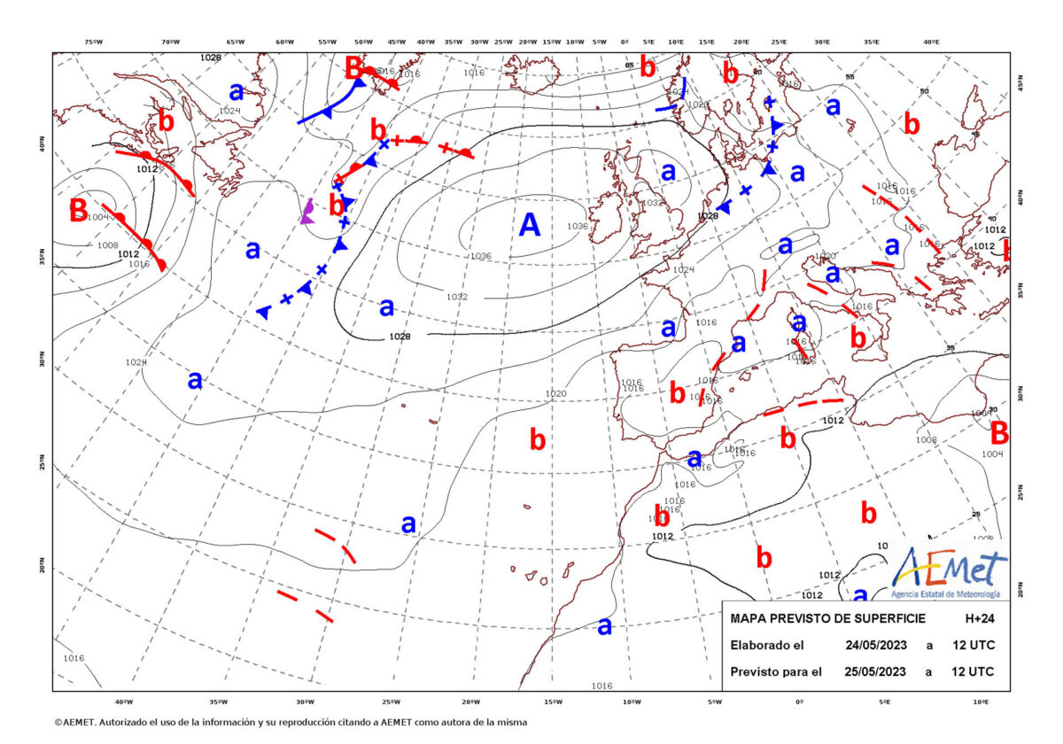
Madrid, May 25 (EFE).- The State Meteorological Agency (Aemet) forecasts for this Thursday showers and storms that could be particularly strong in the eastern third of the peninsula and in the Balearic Islands, as well as intervals of strong winds on the northwest coast of Galicia .
Due to an extensive isolated depression at high levels (DANA), the Aemet announces that instability will persist on the peninsula and the Balearic Islands, with cloudy skies and daytime cloudiness prevailing during the second half of the day.
The agency expects probable showers and storms in large areas of the interior south, center, locally strong in the eastern third of the peninsula and the Balearic Islands; while in the eastern half of the Cantabrian Sea the situation can become unstable at the last minute with showers that may be locally moderate.
In the extreme northwest, the situation will be more stable, since, for example, precipitation is not expected in the south of Galicia, where the skies will be slightly cloudy, with some cloudy intervals of diurnal evolution.
In the Canary Islands, the sky will present cloudy intervals, with evolutionary cloudiness and some isolated showers in the afternoons in the interior of higher relief islands.
Daytime temperatures will be normal for the time of year, with general ascents in the southern half and decreases in the rest of the Peninsula, while the archipelagos will experience few changes.
The wind will blow from the north in the northern half of the peninsula, and with strong intervals on the northwest coast of Galicia; while in the Mediterranean area the eastern component will predominate and in the Canary Islands the northern component and the breezes will do so.
PREDICTION BY AUTONOMOUS COMMUNITY
———————————————————–
-GALICIA: Predominance of slightly cloudy skies, except in the northeast, where there will be intervals of low cloudiness at the beginning or end of the day, which will be accompanied by scattered mists and mists in high areas. Some weak and scattered precipitation in the northeast is not ruled out.
Temperatures unchanged or slightly rising. In the southeast quadrant, variable light wind. In the rest, a light wind from the northeast that at first will be more intense in the northern third and that will intensify and turn from north to south. In exposed points of the coast between Fisterra and Ortegal, there will be strong gusts; while they may be very strong in elevated areas of the western half and also on the southwest coast of A Coruña.
-ASTURIAS: Cloudy intervals. Rains and showers in the east in the afternoon, without ruling them out in the rest in a more isolated way. Minimum temperatures in decline and maximum with slight changes. Light wind from the northeast and east, somewhat more intense and gusty on the coasts, in the extreme west and on the peaks.
-CANTABRIA: Cloudy skies in the interior and cloudy intervals in the rest. Scattered mists and mists in mountain areas both at the beginning and at the end of the day. Rains and showers in the interior during the afternoon, which may be locally somewhat stronger and accompanied by a storm. Minimum temperatures in decline and maximum with slight changes. Wind from the north, generally light, although gusty in the interior and somewhat stronger in the south during the day.
-BASQUE COUNTRY: Predominance of cloudy skies, with the opening of some temporary clearing. Scattered mists and mists in the mountains at the beginning and end of the day. Light rain and scattered showers likely, which may occasionally be accompanied by thunderstorms. Minimum temperatures in decline and maximum with slight changes. Light but gusty wind from the north, on the coasts and the south, more intense during the central hours of the day.
-CASTILLA Y LEÓN: Slightly cloudy with cloudy intervals of low clouds in the east, extreme north and Central System that can cause morning fog banks in mountain areas. that the cloudiness will increase in the afternoon with clouds of evolution, with scattered showers that can go with a storm, more likely in the extreme north, and especially in the southern third, where they will be generalized at night.
Minimum temperatures in decline and maximum temperatures in slight ascent in the west and without changes in the rest. northeasterly wind with strong gusts.
-NAVARRE: Predominance of cloudy skies, with the opening of some temporary clearing. Scattered mists and mists in the northern ranges and mountains, at the beginning and at the end. Light rains and scattered showers in the northern third that cannot be ruled out may be locally stronger in the afternoon, be accompanied by a storm and spread to the rest of the Foral Community at the end.
Falling temperatures. light wind although gusty from the northwest that during the day will be more intense except in Bidasoa. Closing in the Ebro.
-LA RIOJA: Cloudy intervals with evolving cloudiness, without ruling out scattered showers with storms, more likely in Iberica. Morning fog banks are not ruled out in the mountains. Minimum temperatures in decline and maximum without changes or in slight decrease. Northwest or north wind, with strong gusts.
-ARAGÓN: Cloudy intervals with cloudiness of diurnal evolution. Locally strong showers with storms and possible hail are expected, especially in the afternoon and more likely in Huesca and in the south of Teruel.
Maximum temperatures in decline in the northern half and with little change in the rest. In the Ebro valley, moderate northwesterly wind and in the rest, light variable, with a predominance of the northern component in the southern half and the eastern component in the eastern third in the afternoon.
-CATALONIA: Predominance of cloudy skies with locally strong showers, with storms and possible hail. Minimum temperatures without changes and maximum temperatures in a locally notable decrease. Light variable wind, with a moderate north and northwest in the Ampurdán and south of Tarragona in the morning, and with a general tendency to the east and southeast, light to moderate from midday.
-EXTREMADURA: Slightly cloudy sky with evolutionary cloudiness and scattered showers in the afternoon and evening, which can go into a storm. Minimum temperatures unchanged and maximum temperatures rising. Variable wind, with a tendency to the west and northwest, loose and general, which will increase in intensity at night in the north.
-MADRID: Little cloudy with cloudiness of daytime evolution that will increase at the end under cover. Probable scattered weak showers in central hours with an occasional storm that intensifies at the end of the day, especially in the Sierra. Little changed temperatures. Variable light wind, with a predominance of the northern component, which will intensify the eastern component at the end.
-CASTILLA-LA MANCHA: Slightly cloudy with intervals of low clouds in the north of Iberia that will go with associated mists and mists at the summits and abundant cloudiness of diurnal evolution. Light rains, showers and storms from noon, more scattered in the north and more intense, frequent and with hail in the southeast quadrant, which will be strong in the southeast of Albacete.
Minimum temperatures in decline in mountainous areas of Guadalajara and with few changes in the rest; increasing maximums except in Guadalajara and in Cuenca Iberian where they will remain unchanged. Variable light wind, with a predominance of the northern component in the central hours of the day, and that will turn from the late afternoon to the eastern component with more intense intervals in the northern half.
-VALENCIA COMMUNITY: Cloudy intervals in the early hours, which will increase to cloudy or covered with cloudiness of diurnal evolution. Starting at noon, locally strong showers are expected, with a storm and possible hail. Maximum temperatures in decline in Castellón and in ascent in the south of Alicante. Variable light wind, with a moderate northwest in the northern interior of Castellón in the morning, and with a tendency to an easterly component at noon in general.
-MURCIA: Skies with cloudy intervals in the morning that will increase to cloudy during the day, with showers, more likely and intense in the afternoon and inland, where they will be occasionally accompanied by storms and hail and can be locally strong. Possible morning mists. Rising maximum temperatures. Variable wind, generally light, with a tendency to the southwest on the coast.
-BALEARIC ISLANDS: Cloudy intervals with occasional rainfall accompanied by mud, which in the afternoon in the Pitiusas and Mallorca could be locally strong and be accompanied by storms and hail. Little changed temperatures. Light east and northeast wind with coastal breezes.
-ANDALUCÍA: Sky with intervals of low morning clouds and increasing cloudiness throughout the day, without ruling out occasional showers accompanied by storms and hail, certain and more intense during the afternoon in the eastern interior, central areas, and in the mountain ranges of the rest, and that they may be locally strong. Probable morning fog banks.
Rising temperatures, or locally minimum without changes. Light variable wind, with a tendency to a west or southwest component on the Mediterranean coast and the Atlantic slope.
-CANARY ISLANDS: Cloudy intervals with a tendency to become cloudy from noon. Low probability of light and occasional rains, they will be more likely in inland areas of the mountainous islands in the afternoon. Little changed temperatures. Light northeast wind. Breezes on the coasts.