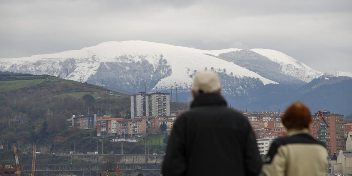
Madrid, Jan 26 (EFE).- The snowfall will continue this Thursday in the Cantabrian Mountains, with significant accumulations at higher elevations, and that will also occur in the Central, Iberian, Betic and Pyrenees systems, with decreasing maximum temperatures and frosts widespread in the interior of the peninsula, according to the forecasts of the State Meteorological Agency (Aemet).
Rainfall will be recorded in the Cantabrian area, where it may be persistent in the mountains, and will also be accompanied by an occasional storm, and will spread weakly to the rest of the northwestern third and occasionally to other areas.
In the Balearic Islands, probable occasional showers, without ruling out that they reach Melilla.
In the Canary Islands there will be cloudy intervals that will decrease to slightly cloudy in the north of the islands of greater relief, and little cloudy in the rest.
The snow level will be located in the Pyrenees and north of Navarra at 400-600 meters; in the Cantabrian and northern Iberian mountains in 800-1,000 meters and in the rest of the northern half and Betic systems 600-900 meters, with significant accumulations in the Cantabrian and Central and Iberian systems.
The maximum temperatures will drop, the minimum ones also in the southwestern quadrant of the peninsula, eastern Catalonia, areas of the Levant and the Canary Islands, but they will increase in the rest, leaving weak frosts widespread in areas of the interior of the peninsula, reaching strong temperatures in the Pyrenees.
There will be trade winds in the Canary Islands, getting worse and reaching strong, with very strong gusts in the western islands; west in the Strait and Alborán, where it will become strong, although worsening in both.
Of northern component in the rest, weak in the western half of the peninsula and more intense in the east and coasts, reaching strong or very strong gusts in the Ebro, Ampurdán and north of the Balearic Islands; Throughout the day, it will tend to subside in the Levant and worsen in the northwest of the peninsula, becoming strong with very strong gusts on the coasts of Galicia.
PREDICTION BY COMMUNITIES:
– GALICIA: cloudy sky, with probable mists and morning mists in the mountains to the east and south of Ourense. Light rains and showers in the northern half that will be more intense in the northeast, where they may be accompanied by occasional storms; in the rest light rains without ruling out an occasional shower during the afternoon. The snow level between 1,000-1,200 meters down to 800-1,000 at the end of the day.
Minimum temperatures without changes or slightly rising, leaving weak frosts in the southeast quadrant, somewhat more intense in mountain areas; maximum without significant changes except in the interior mountains, where they will drop slightly. On the coast, wind from the north component, with probable very strong gusts in exposed points of Finisterre; in the interior, light wind from the north component, with more intense intervals in the central hours of the day.
– ASTURIAS: cloudy sky, with probable mists and morning mists in the Cordillera. Widespread precipitation and showers occasionally accompanied by storms in the afternoon, which may be persistent, as well as locally strong in the Cordillera. The snow level between 800 and 900 meters, temporarily increasing to 1,100.
Rising minimum temperatures, more pronounced in the southwest, with weak frosts in the Cordillera; maximum in light descent in the Cordillera and without changes in the rest. Light wind from the north component, more intense on the coast, where there will be strong intervals starting at noon.
– CANTABRIA: cloudy with mists and fog banks in the mountains. Generalized persistent rainfall and showers, occasionally accompanied by a storm in the afternoon, without ruling out that they are locally strong in the interior. The snow level between 800 and 900 meters. Minimum temperatures slightly rising, leaving weak frosts in the southwest; maximum without changes or in slight ascent. Light wind from the north component, with more intense intervals on the coast and in exposed areas of the mountains.
– BASQUE COUNTRY: cloudy sky, with probable morning mists and mists in high inland areas. Generalized rainfall and showers that may be accompanied by a storm in the afternoon, less abundant the further south. The snow level is around 700 and 900 meters, going down to 400 at the eastern end. Rising temperatures, although with weak frosts in the northeast. Loose wind from the north component, of greater intensity on the coast and in exposed areas of the mountains.
– CASTILLA Y LEÓN: in the northern third, east and Central System, cloudy with light rainfall, especially in the second half of the day, and may be persistent in the extreme north; in the rest, cloudy intervals with probable weak precipitations, mainly in the afternoon. The snow level will be between 800 to 1,000 meters in the north, and 600 to 900 in the rest. Rising minimum temperatures that will leave widespread frosts, and decreasing maximum temperatures in the northwest and unchanged in the rest. Wind from a northwesterly direction that will tend to the north and northeast in the central hours of the day, with strong gusts in mountain areas.
– NAVARRE: cloudy sky, with probable mists and morning mists in the northern third. Weak widespread precipitation, accompanied by an occasional storm in the northwest. The snow level of 300-400 meters in the Pyrenees and 500-800 in the rest. Rising temperatures, locally more pronounced in the minimum, although with locally intense frosts in the Pyrenees and weak in the rest, except in the southern third. Wind from the northwest direction, with more intense intervals in the south and east.
– LA RIOJA: cloudy, with weak rainfall in the Iberian region, more intense in the west and southwest, and probable weak rainfall in the Ribera de la Rioja Alta. The snow level from 600 to 800 meters, tending to drop. Minimum temperatures on the rise and maximum temperatures unchanged, leaving weak frosts in the Iberian region. Northwest wind, with strong gusts in the mountains.
– ARAGÓN: in the Iberian System, cloudy skies decreasing to cloudy intervals during the afternoon, with probable weak precipitations in the morning and snow level between 600-800 meters; in the rest, cloudy intervals in general, with a predominance of cloudy skies in the Pyrenean divide, where weak precipitations are not ruled out during the morning, with the snow level between 400-600 meters.
Minimum temperatures rising or unchanged, with widespread frosts, locally strong in the Pyrenees and non-existent in the Ebro depression; maximums in descent in the Pyrenees and the Iberian System, without changes in the rest. Moderate wind from the north in the Pyrenees and from the northwest in the rest; with strong intervals and very strong gusts in the upper Ebro, at high levels of the Pyrenees and to the north of the Iberian System.
– CATALONIA: in the Aran Valley, cloudy skies with probable light rainfall during the morning, and snow level between 400 and 600 meters. In the rest, little cloudiness except for some intervals of low clouds in the early hours in the western interior and in the afternoon in the northeast. Minimum temperatures rising in the Aran Valley, falling in the eastern half and unchanged or slightly rising in the rest, which will leave frost in the interior, locally strong in the Pyrenees; maximums in descent in the eastern half, in slight descent in the north of Lleida and without changes or in slight ascent in the rest.
Moderate to strong wind with very strong gusts, from the north in Ampurdán and from the northwest in the south of Tarragona; In the rest, variable light wind in general, with moderate intervals from the north, occasionally strong at high levels of the Pyrenees.
– EXTREMADURA: slightly cloudy increasing at cloudy intervals, without ruling out some scattered weak precipitation, especially in Gredos. The snow level between 600 to 800 meters. Minimum temperatures with slight changes and maximum temperatures without changes or in slight decrease, leaving generalized weak frosts, unlikely in the west. North component wind.
– COMMUNITY OF MADRID: cloudy sky, although with large clearings on the plateau in the early hours, where it will decrease to slightly cloudy at the end of the afternoon. Morning mists and mists at high altitudes of the Central System. Weak precipitation in the form of snow in the Sierra in the morning. Minimum temperatures without changes or in general slight rise, with widespread weak frosts, occasionally more intense in the Aranjuez area.; highs in slight decline, somewhat more pronounced in the Sierra. North component wind, temporarily turning west and northwest in the morning and blowing more intensely in the Sierra.
– CASTILLA-LA MANCHA: covered in the northeast and cloudy intervals in the rest, decreasing from late afternoon to slightly cloudy throughout the Community. Morning mists and mists at high altitudes in the northeast. Probably weak rainfall in the northeast that cannot be ruled out in the Alcarria de Guadalajara and in points of Albacete; in the afternoon they are restricted to the mountains of Alcaraz and Segura.
The snow level will be between 600-800 meters, rising in the southwest of Albacete to 800-1,000. Minimum temperatures without changes or in general slight rise, with widespread weak frosts; maximums without changes or in slight decrease, more pronounced in the southeast quadrant. Wind from north and northwest directions, loose with more intense intervals in the eastern half and in La Mancha de Toledo.
– VALENCIAN COMMUNITY: cloudy intervals, more abundant in the northern interior in the morning. Temperatures without significant changes with frost in inland areas. In the north of Castellón, moderate northwesterly wind, with strong intervals and very strong gusts in the interior; in the rest, light to moderate wind from the west component.
– REGION OF MURCIA: slightly cloudy sky increasing to cloudy. Temperatures without changes, or maximum temperatures in decline in the interior, with weak frosts in the interior. Northwest direction wind.
– BALEARIC ISLANDS: cloudy intervals, with occasional and scattered showers, preferably in Majorca, which could be accompanied by small hail. The snow level in the 800 meters. Decreasing night temperatures, with weak frosts in Mallorca, and daytime temperatures with few changes. North component wind, with strong intervals and gusts of 60 to 70 kilometers per hour Menorca.
– ANDALUSIA: slightly cloudy skies increasing to cloudy during the day, without ruling out weak rainfall starting in the afternoon in the interior mountains and area of the Strait. The snow level above 600-800 meters. Temperatures unchanged or falling, with frosts in the interior, generally weak. Wind from west or northwest directions on the Mediterranean coast with strong intervals in the afternoon; of northern component in the rest and west in the Strait with strong intervals in the afternoon.
– CANARY ISLANDS: cloudy intervals in the north of the islands with the highest relief, and in the rest of the areas, a predominance of slightly cloudy skies with intervals of high clouds. Little changed temperatures. Moderate to strong northeasterly wind, with very strong gusts on the northwest and southeast slopes of the higher relief islands, as well as on exposed peaks, especially on the island of La Palma and the northwest slope of La Gomera.